ENVIRONMENTAL INFORMATION CENTRE IN NATURA 2000 NETWORK AREA, SALTLAKES, LARNAKA
European Architectural Competition for “the design of an environmental information centre in Natura 2000 Network Area, in Salt Lakes, Larnaca ”
Status: competition entry, design proposal
Principle Architects: Maria Hadjisoteriou, Antonis Peratikos
Collaborators: Thanos Stergiou, Savvas Savva
Location: Natura 200 Network Area in Salt lakes, Larnaca
Date: 2025
Client: Larnaca Municipality
DESIGN PARAMETERS
During our site exploration, we observed that the building’s proposed location occupies an unfavorable position in relation to the view. At the same time, we recognized both the need to protect the sensitive habitat and the visitor’s need to engage with the uniquely beautiful landscape of Alyki. This dual condition became the starting point for the project’s main design principle.
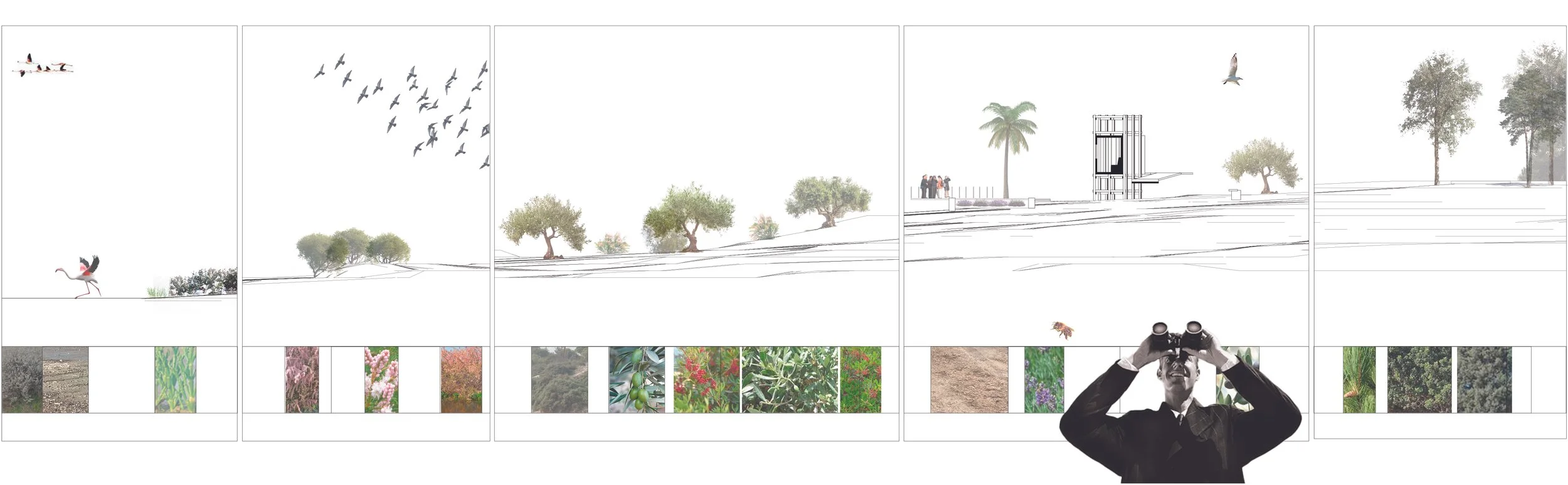
The central concept is based on the notion of landscape experience, with an emphasis on the alternation between moments of visual exposure and concealment of the Alyki landscape. Through the process of movement and exploration, the visitor experiences a sequence of spatial and visual transitions, where the landscape is strategically revealed and obscured, enhancing its experiential perception.
The Environmental Center does not function as a final destination, but rather as an intermediate stop along the path of the walker–visitor, providing infrastructure for research, information, and education, while maintaining a direct yet controlled relationship with the natural environment.
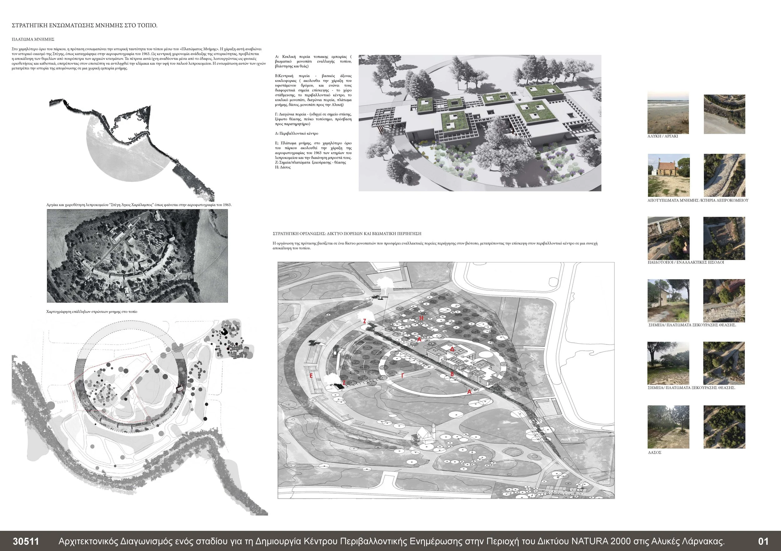
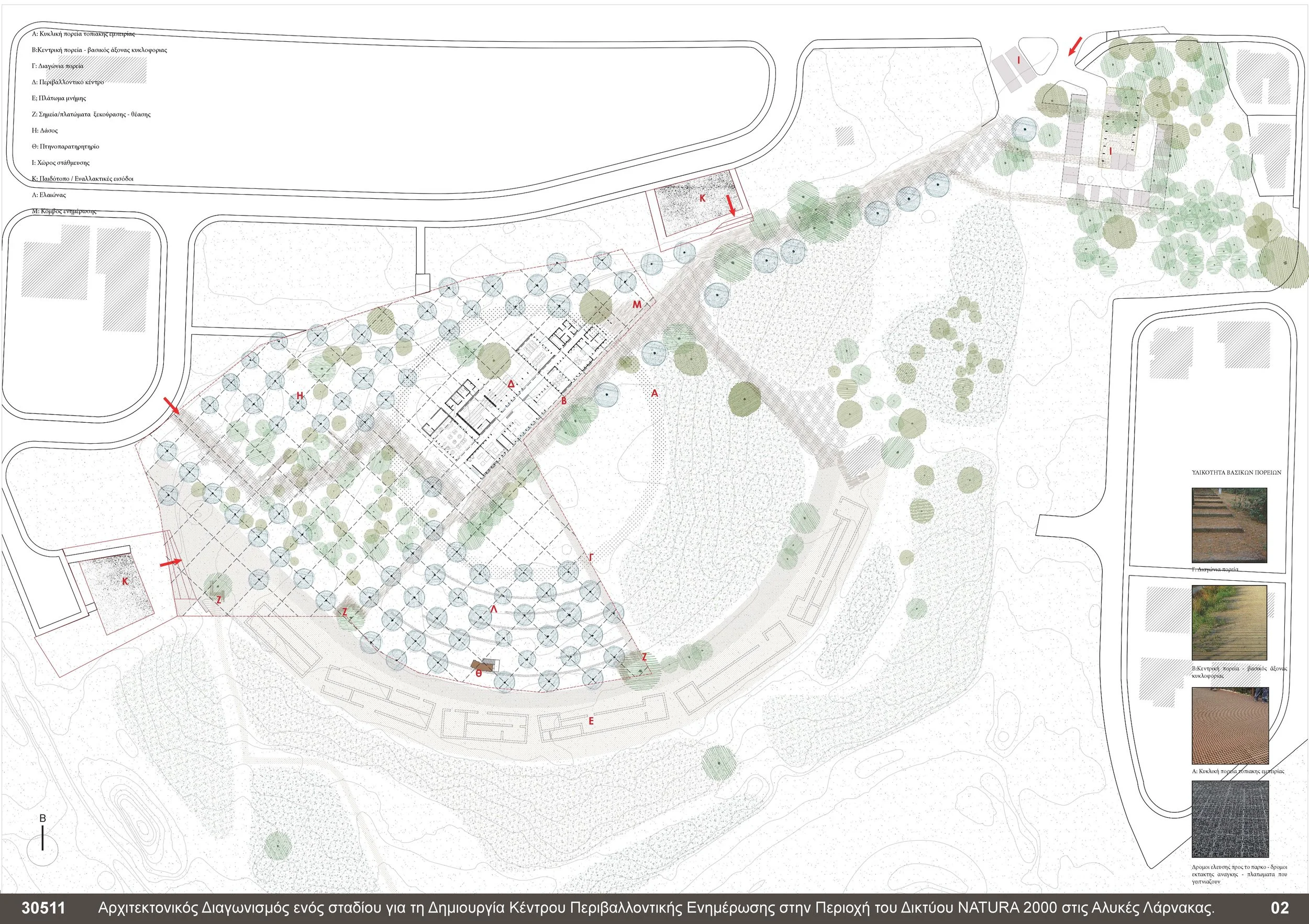
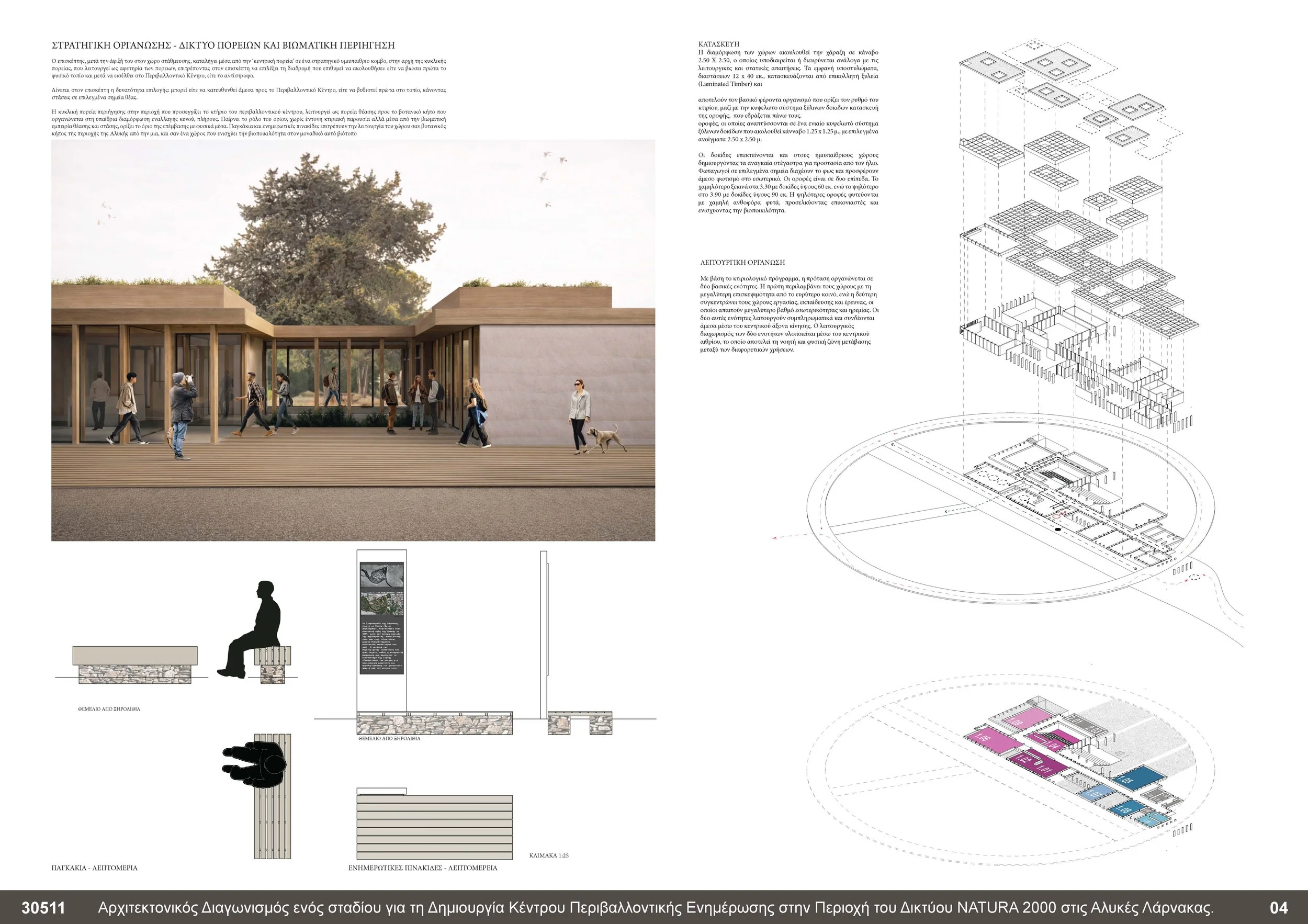
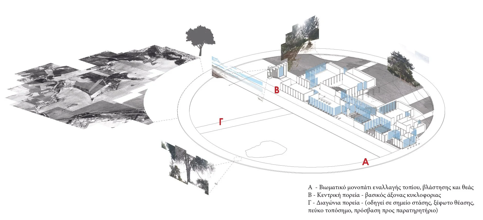
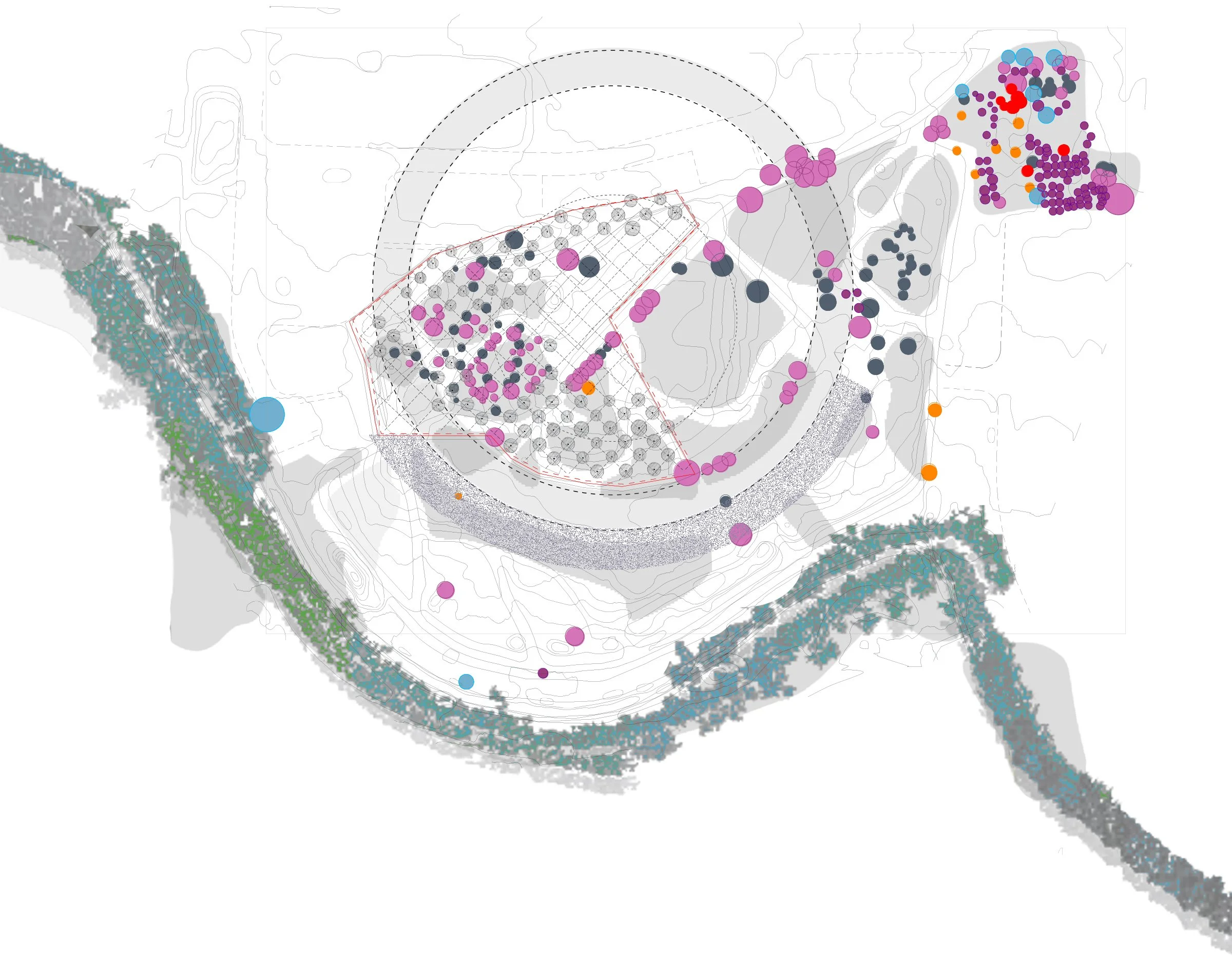
ORGANIZATIONAL STRATEGY – NETWORK OF PATHWAYS AND EXPERIENTIAL CIRCULATION
The organization of the proposal is based on a network of pathways that offers alternative routes of movement through the habitat, transforming the visit to the Environmental Center into a continuous process of landscape revelation. The primary components of this network include:
A – Experiential pathway of alternating landscape, vegetation, and views – a circular route of landscape experience
B – Central pathway – primary circulation axis
Γ – Diagonal pathway – leading to a stopping point, a viewing clearing, a landmark pine tree, and providing access to the bird observatory
Upon arrival at the parking area, the visitor follows the central wooden pathway, which runs parallel to the permitted vehicular access road, and reaches a semi-open node at the beginning of the circular route, marking the starting point of the path network. From this point, the visitor may choose either to proceed directly to the Environmental Center or to first immerse themselves in the landscape by following the experiential routes and pausing at designated viewing points.
Experiential Pathway of Alternating Landscape, Vegetation, and Views (a)
(Circular route of landscape experience)
The alignment of the circular route follows the southern edge of the +9.00 m contour line, defining the highest viewing level toward the Alyki lagoon. Along this path, the landscape is gradually revealed through the alternation of dense tree clusters and open visual clearings. At the intersection of the circular and diagonal pathways, the visitor is given the option to follow the diagonal route, which leads to the central “plateau of memory and view,” reinforcing the experiential and perceptual reading of the landscape.
As the terrain slopes downward toward the north, the route follows the natural topography, guiding the visitor through the existing landmark forest of the area, characterized by dense pine and cypress vegetation, after optionally crossing the central pathway. Continuing along the route, the visitor moves alongside the botanical gardens before the path completes its loop and returns to its point of origin. In its final phase, the pathway defines the botanical gardens of the Environmental Education Center as a unified functional ensemble, integrating landscape and built infrastructure.
The circular pathway is constructed as a lightweight metal structure, slightly elevated above the natural ground (15–20 cm), utilizing a perforated metal grating made of Corten steel, allowing for the penetration and growth of low vegetation.
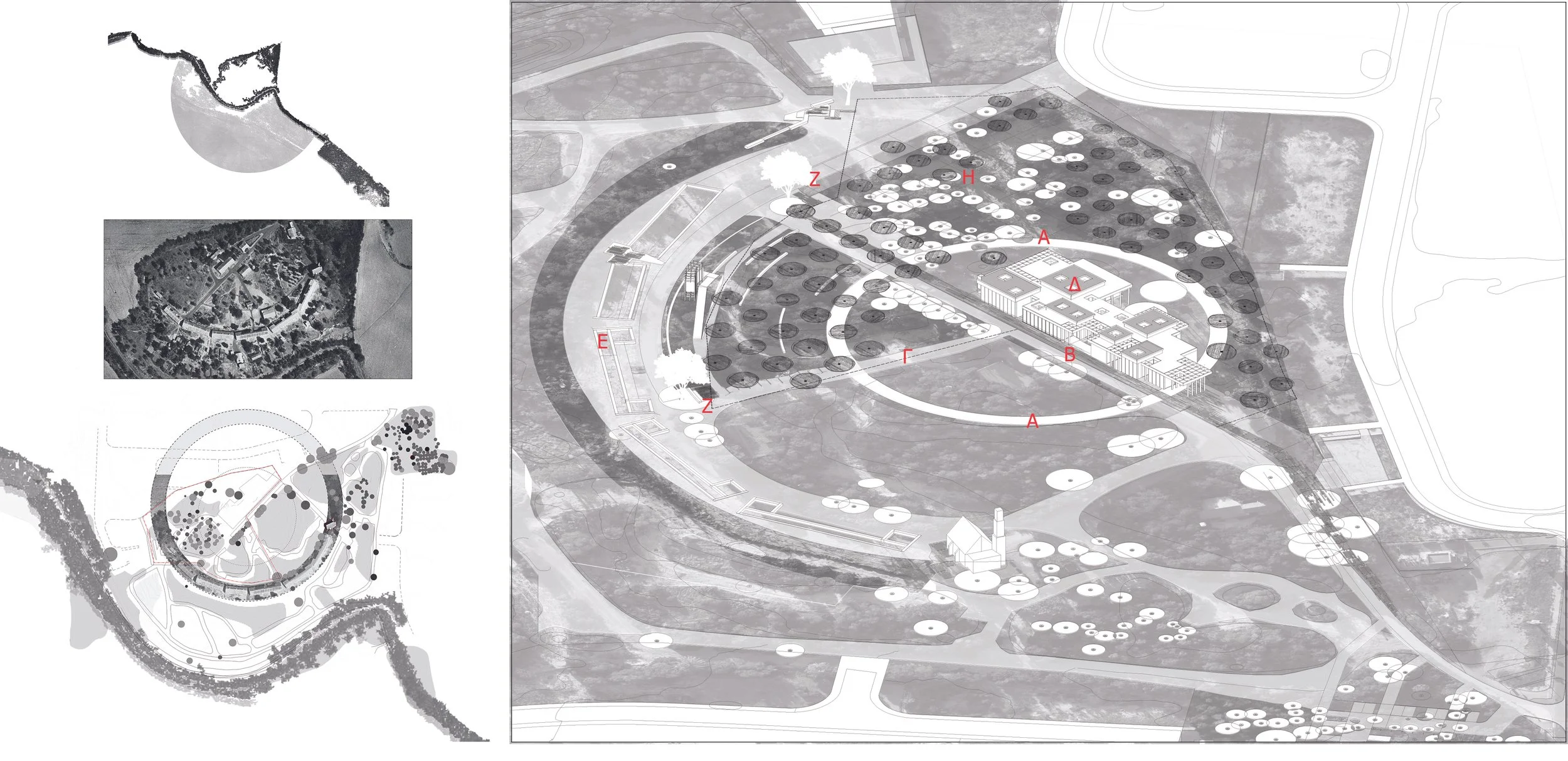
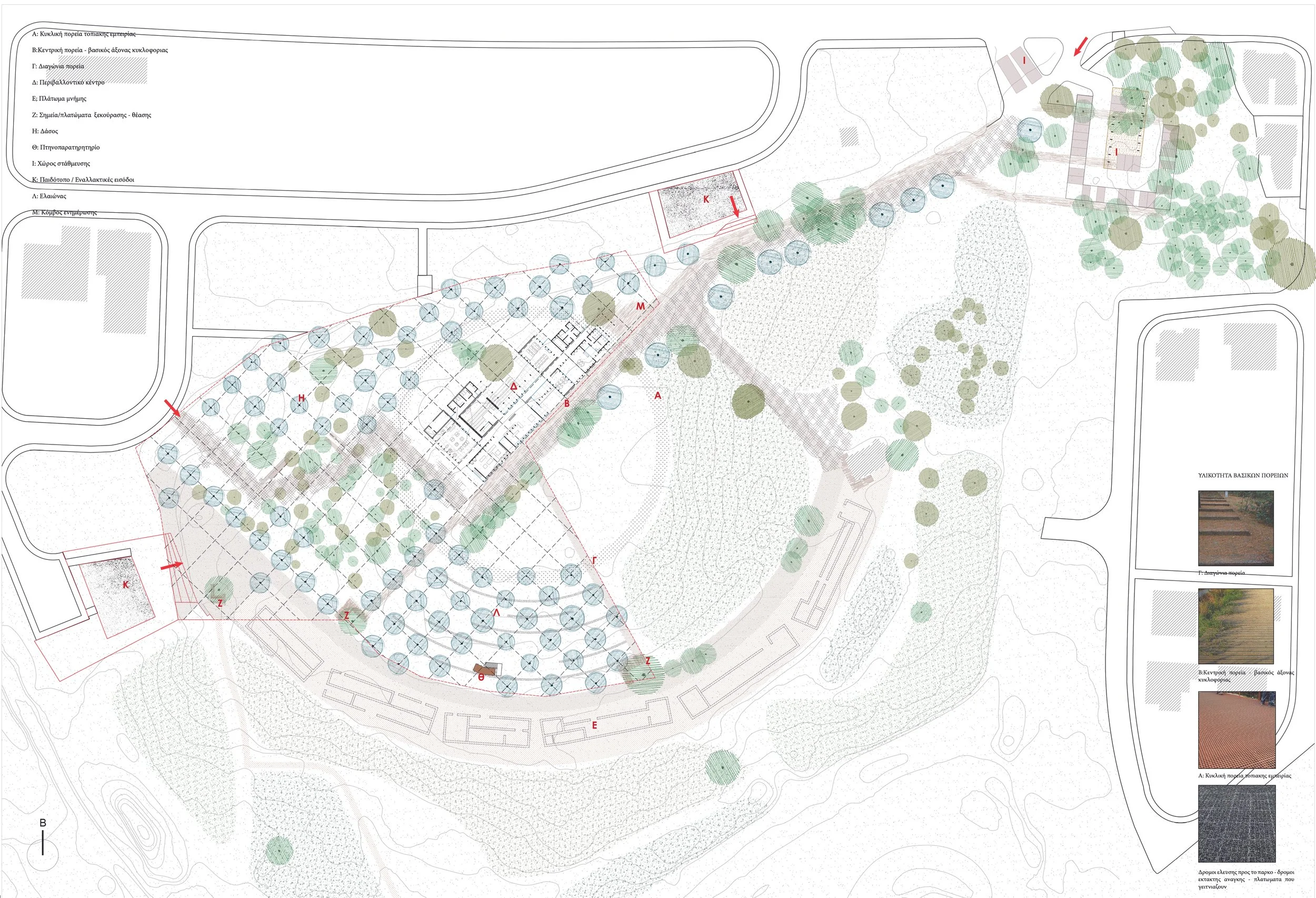
MEMORY plateau (E)
At the lower boundary of the park, the proposal integrates the historical identity of the site through the “Plateau of Memory.” The layout revives the historic settlement of “Stegi Agios Charalambos”, as recorded in the 1963 aerial photograph. As a central gesture highlighting the site’s historicity, the exposure of the rubble-stone foundations of the original buildings is proposed. These stone traces emerge from the ground, allowing the visitor to perceive the scale and material texture of the former leprosarium. The incorporation of these remnants transforms the history of isolation into a spatial experience of memory.
VIEWING PLATEAUS (Z)
Two large pine trees located at the termini of the central and diagonal pathways are transformed into landmarks through the formation of resting and viewing platforms overlooking the wetland. In addition, the creation of another viewing plateau is proposed at the beginning of the pathway leading toward the lake level, serving both to define the route and to allow for the enjoyment of the existing views.
FOREST – OUTDOOR RECREATION (H)
The “forest” is located at the northwestern edge of the site and is characterized by dense pine and cypress vegetation. The proposal suggests extending the vegetation and activating the area as an outdoor recreational zone, incorporating picnic spaces. This area is supported by the Center’s café, as it is located in close proximity to this zone.
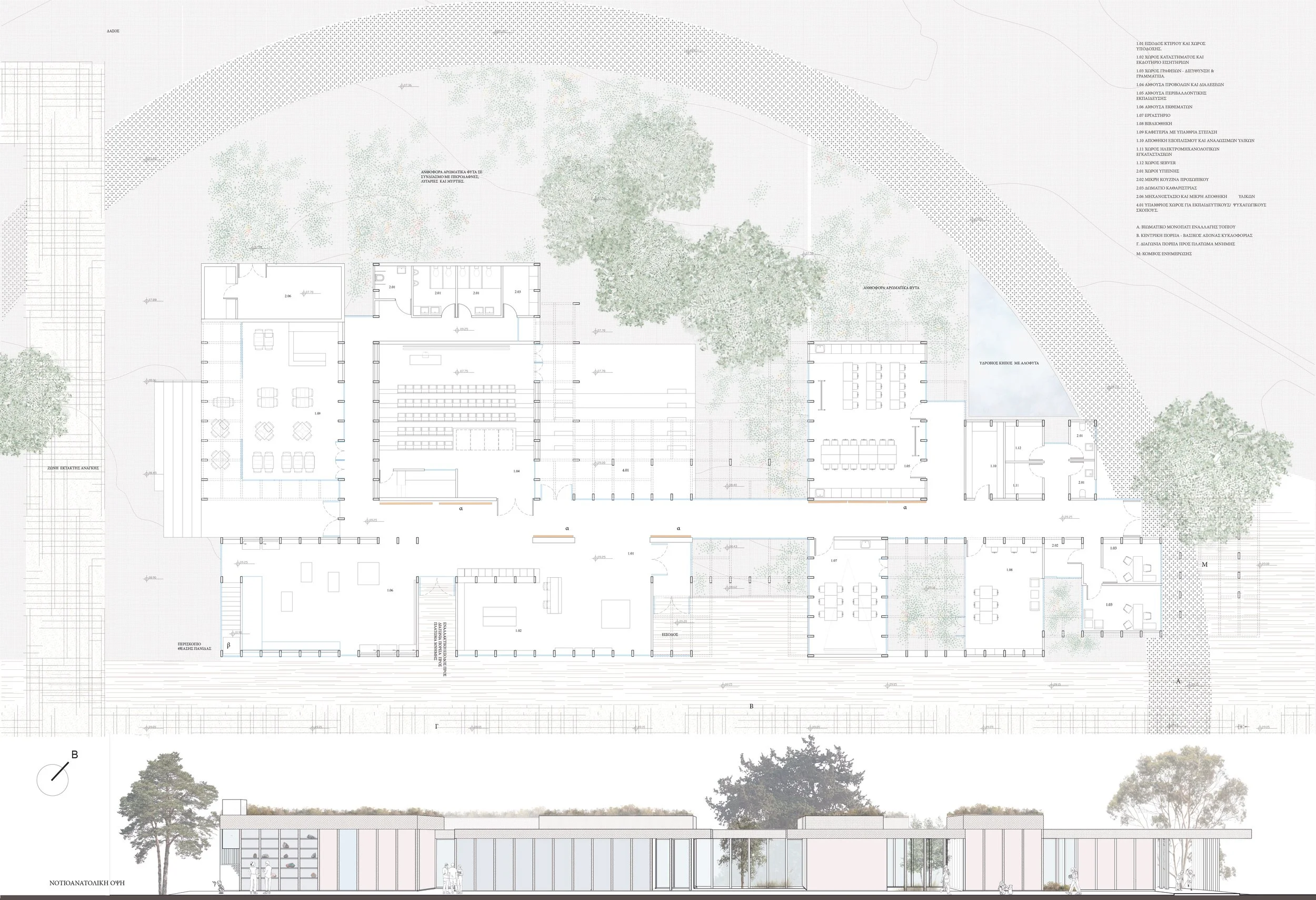
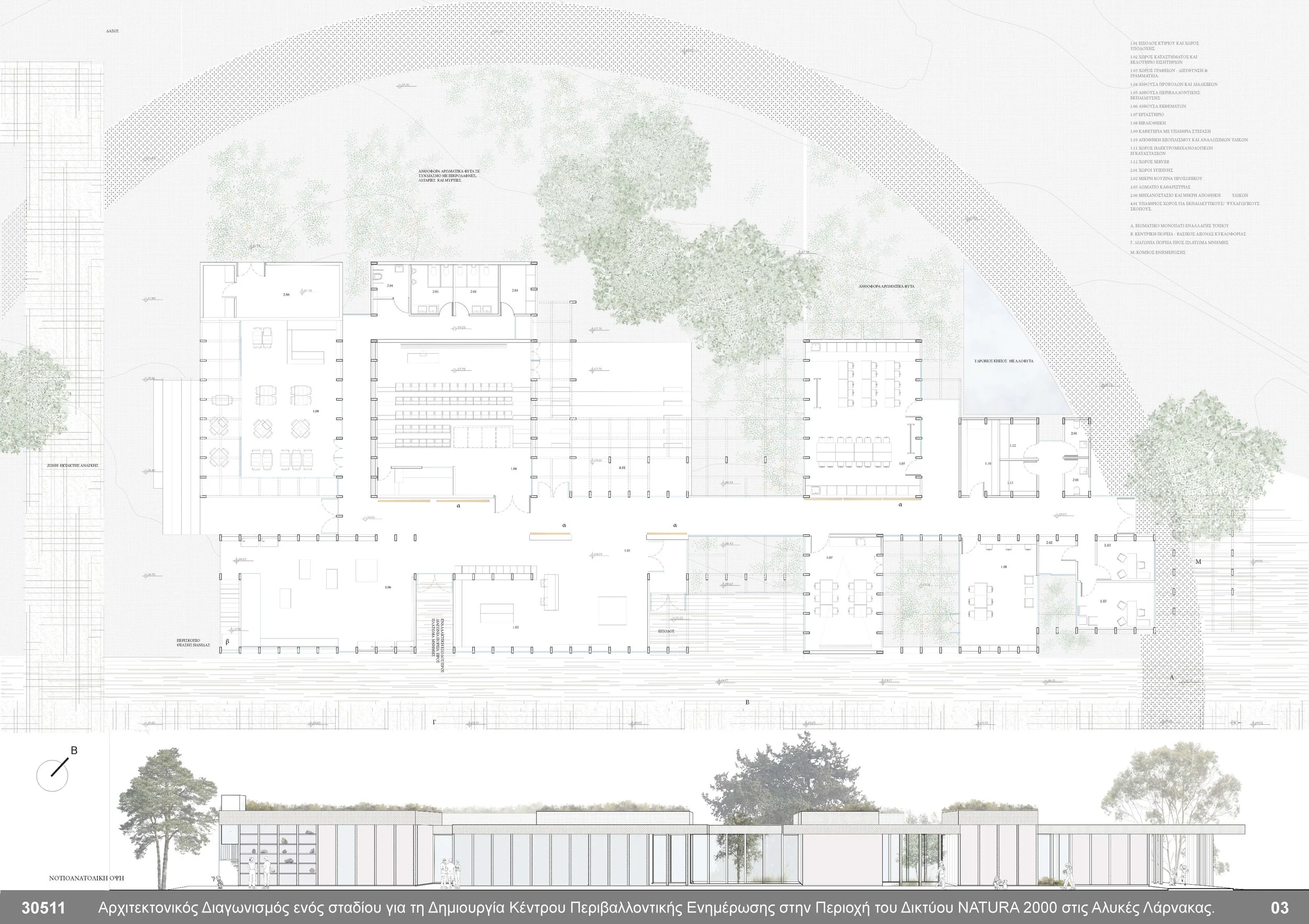
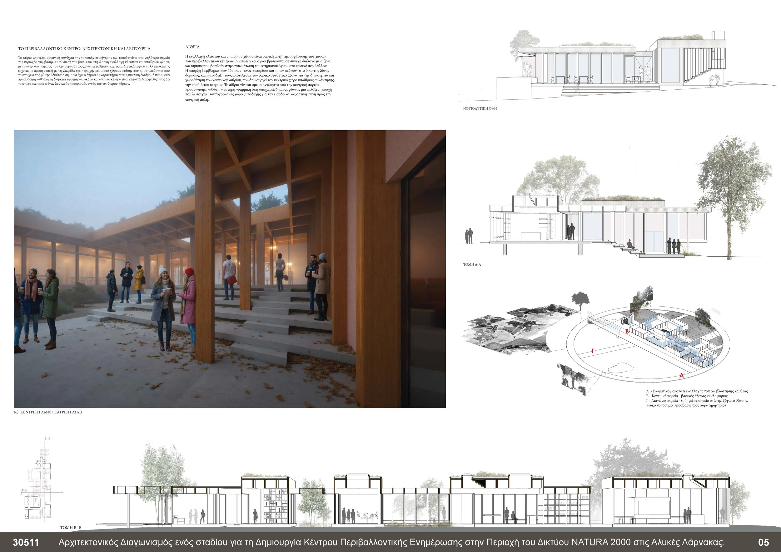
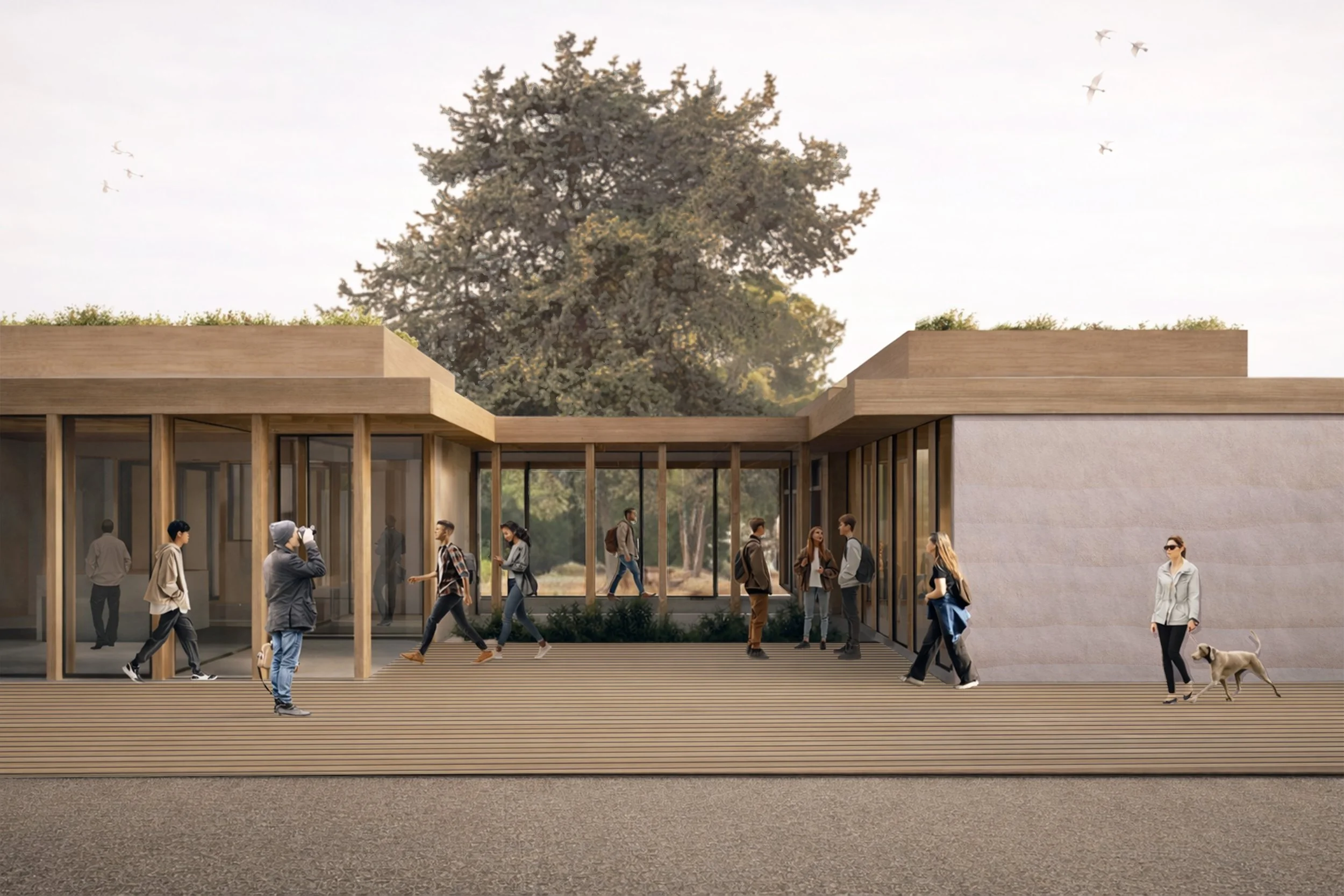
THE ENVIRONMENTAL CENTER (δ)
The building constitutes an organic continuation of the landscape promenade and is positioned at the highest point of the intervention area, following the +9.00 m elevation contour. A fundamental design principle is the continuous alternation between enclosed and open-air spaces, with interior gardens functioning as living exhibits and educational tools, offering visitors direct contact with the local flora. The circular route ensures continuous accessibility to the botanical gardens throughout the day.
The proposal is organized into two primary programmatic zones: the first accommodates areas of high visitor activity, while the second consolidates workspaces, educational facilities, and research areas that require a greater degree of quietness. The two zones are connected via the main circulation axis and are functionally separated by the central atrium, which operates as a natural transitional zone.
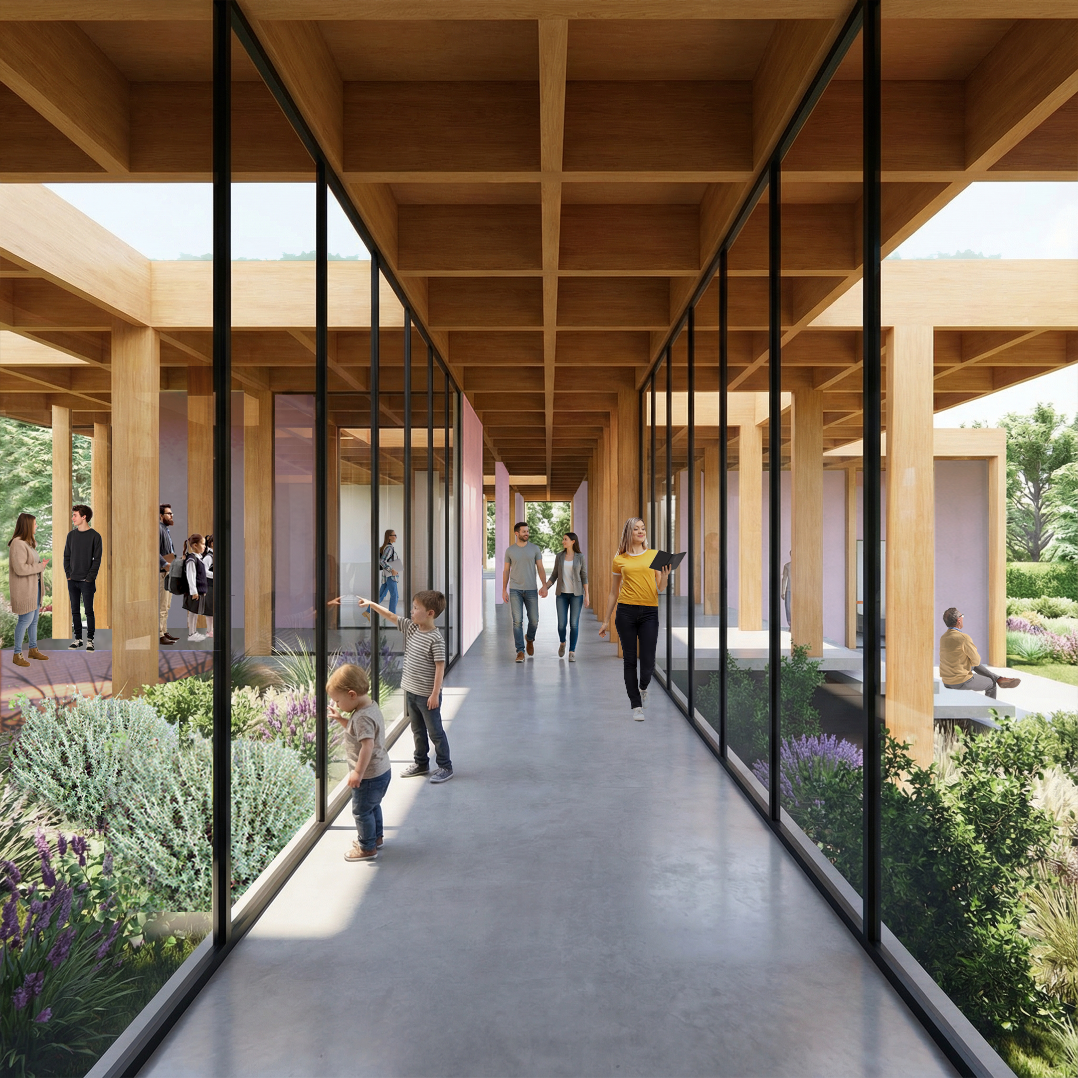
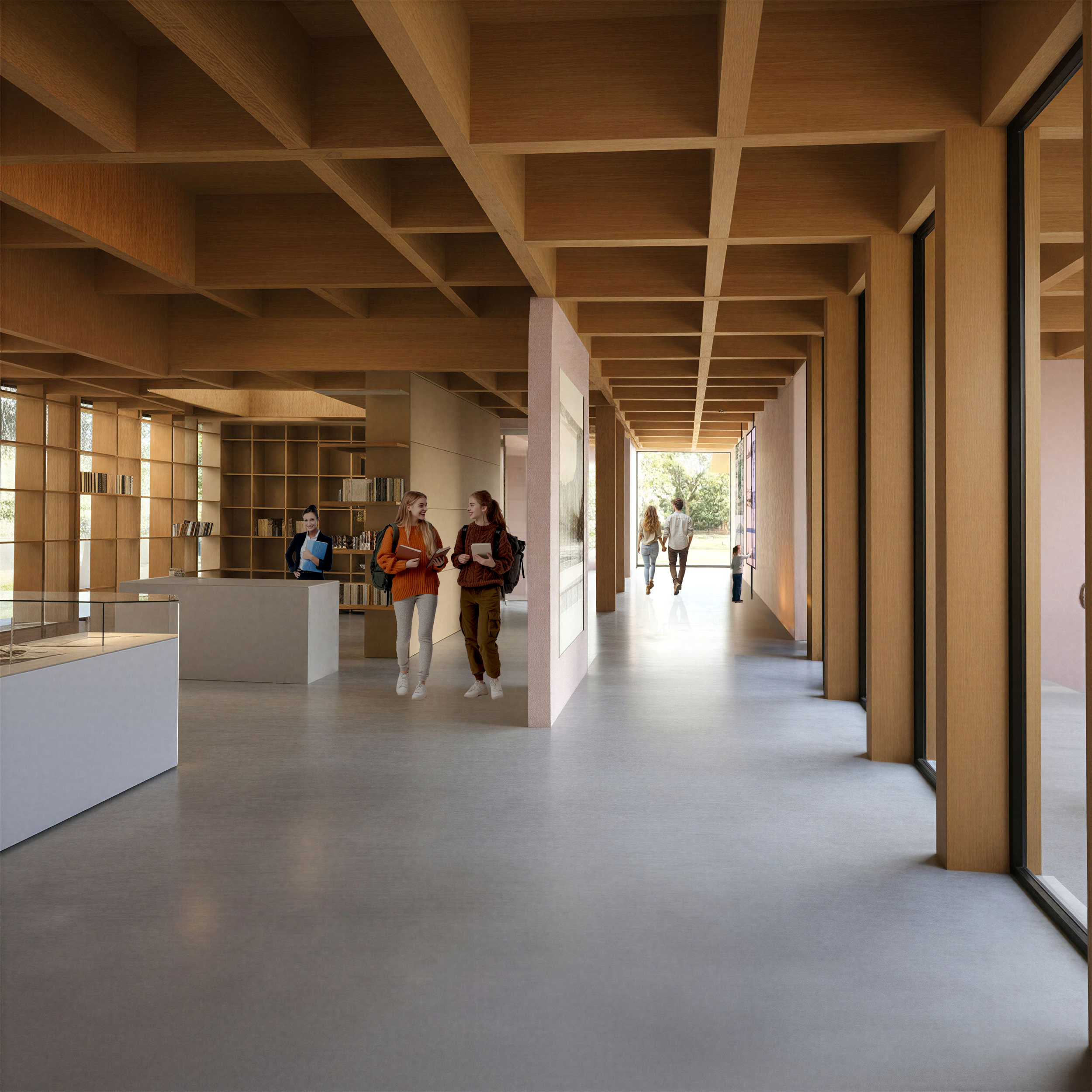
INTERNAL PATHWAYS – EXPERIENTIAL SEQUENCE
The internal pathways constitute a fundamental component of the composition, shaping an experiential sequence characterized by the continuous alternation of spatial scenes. Circulation routes frame intermediate gardens, which function as open-air exhibits. Through this organizational strategy, movement paths are transformed into instruments of information and environmental awareness, enabling visitors to engage directly with the site’s unique habitat and rich biodiversity, thereby reinforcing the educational role of the Center.
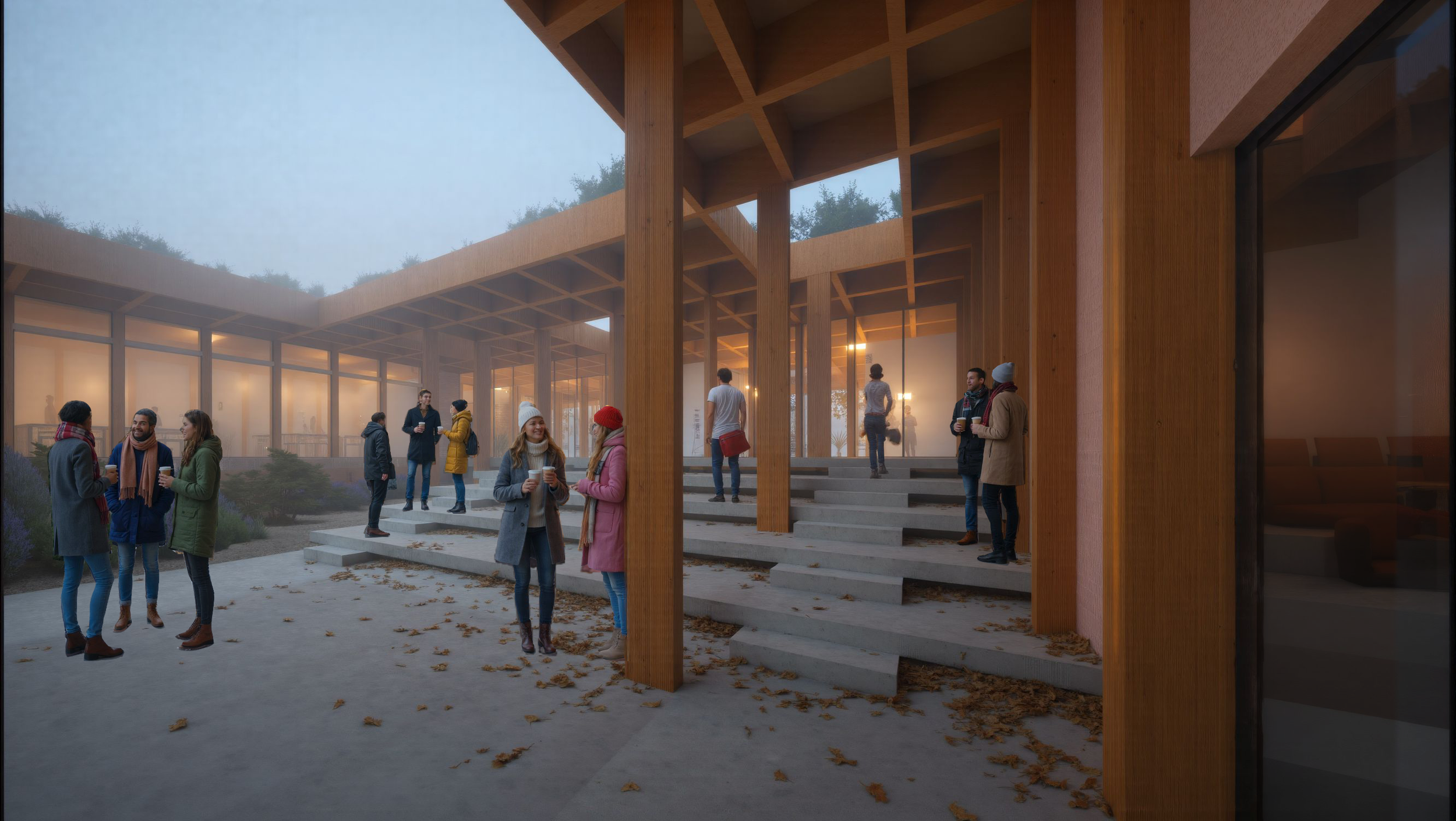
AMPHITHEATER – CENTRAL ATRIUM
The amphitheater fully exploits the natural topography of the site. Access is provided from the highest point, while the seating tiers descend in stepped formations toward the level of the central atrium. The outdoor space is organized amphitheatrically, following the natural contours of the terrain. This configuration creates an open-air viewing space framed by three iconic pine trees and a cypress, which served as the source of inspiration for the creation of this “green embrace.”
ENTRANCE
The entrance area is in continuous dialogue with the central atrium. The outdoor amphitheater also functions as a waiting area for visitors prior to ticket issuance. The circulation space expands into an enlarged plateau for pause and viewing, oriented toward the surrounding trees and the central courtyard.
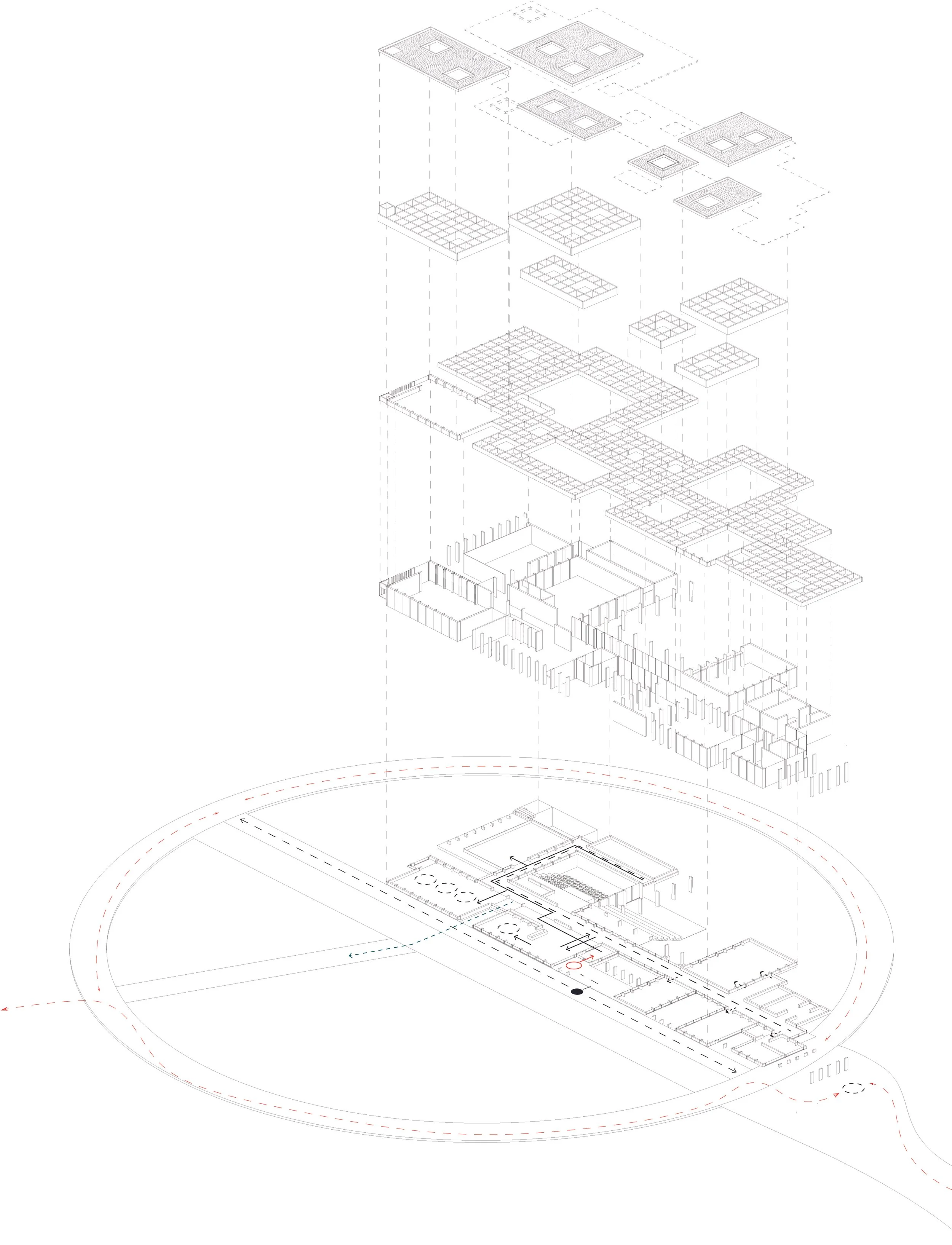
ARCHITECTURAL SYSTEM
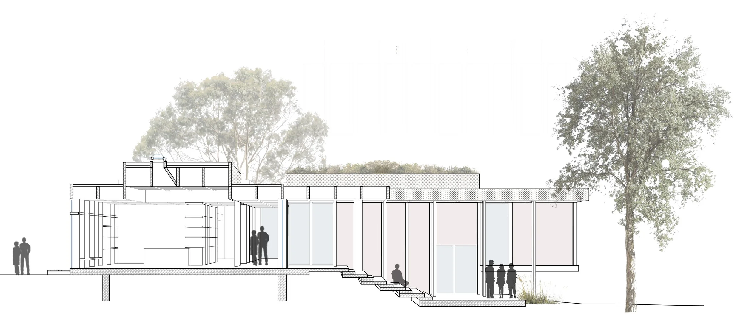
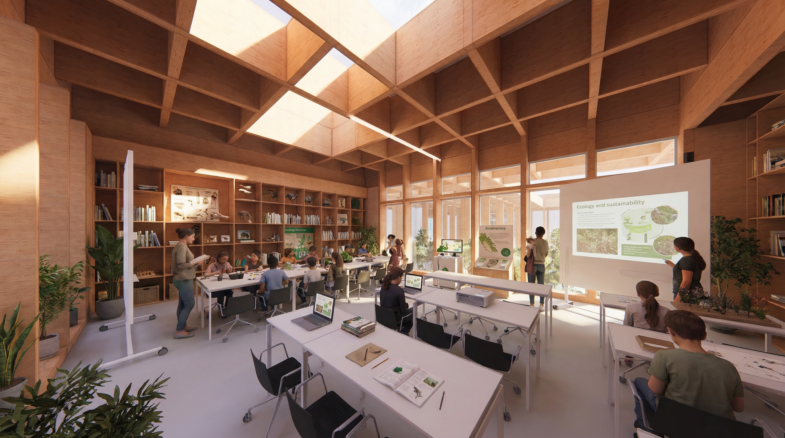
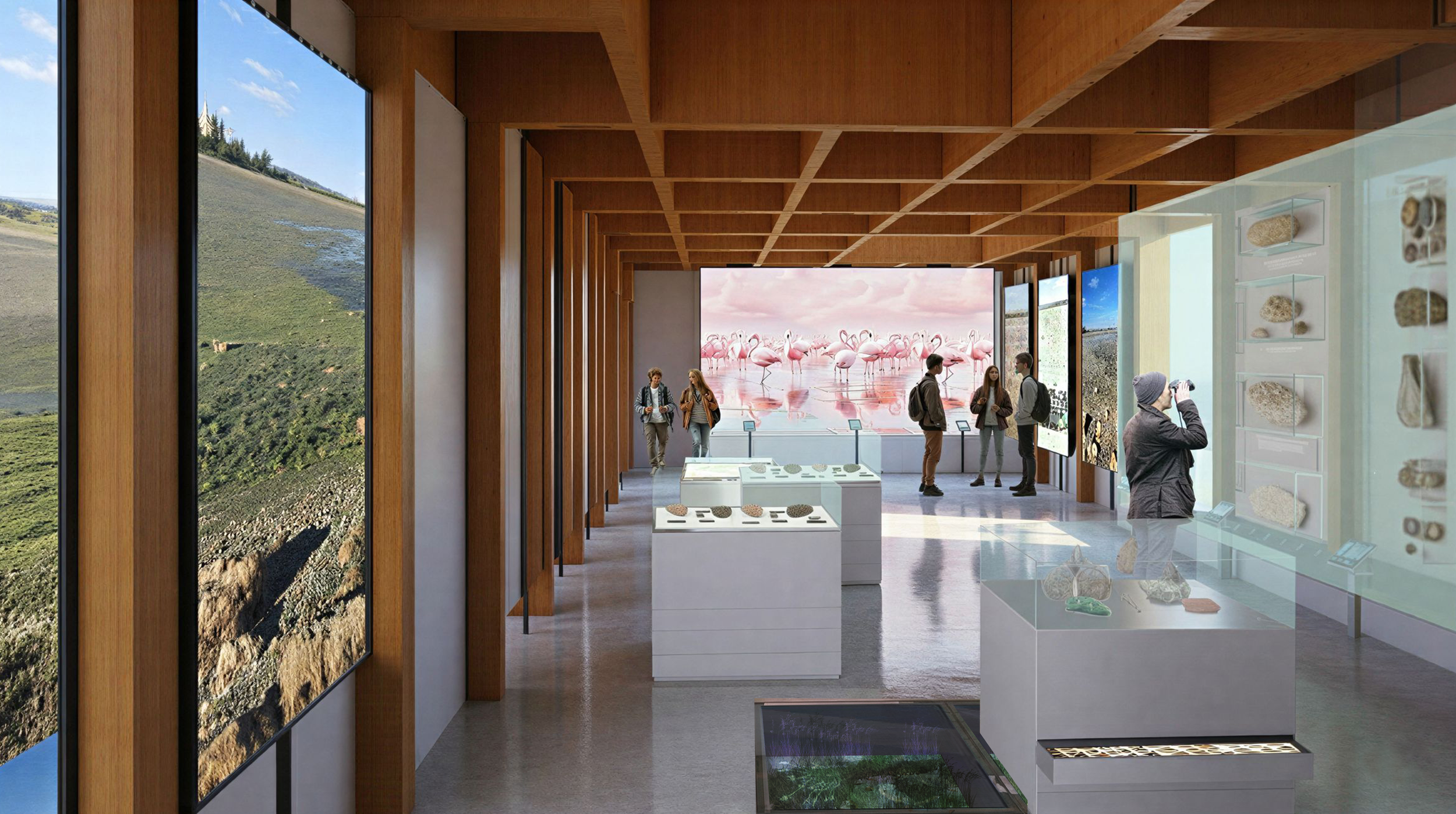
The spatial configuration follows a 2.50 × 2.50 m grid, which is subdivided or expanded according to functional and structural requirements. Glulam columns (12 × 40 cm) constitute the primary load-bearing system, establishing the building’s structural rhythm together with the cellular wooden roof system that rests upon them.
The concrete base, which forms the main circulation level, projects outward in order to minimize ground disturbance. Its surface is treated as a continuous cast terrazzo finish, creating a deliberate contrast with the timber structure above.
The wall construction draws from the traditional pagdati technique, employing a timber frame of local Cypriot pine at 1 m intervals, with horizontal battens made of recycled timber, branches, and reed. The infill is finished with a plaster mixture of earth, straw, lime, and sand, incorporating crushed shells and marble dust.
The roof structure is developed as a cellular system of wooden beams (1.25 × 1.25 m), with selected openings of 2.50 × 2.50 m, and extends into semi-outdoor spaces to form canopies. Skylights diffuse natural light into the interior. Two roof height levels are employed (3.30 m and 3.90 m); the higher roofs support low vegetation, enhancing biodiversity and facilitating the building’s integration into the landscape.
The structural grid of columns establishes a stable rhythm that allows for the organic integration of exhibits, shelving, fixed furniture, and openings within the interstitial spaces, forming a cohesive and legible architectural system.
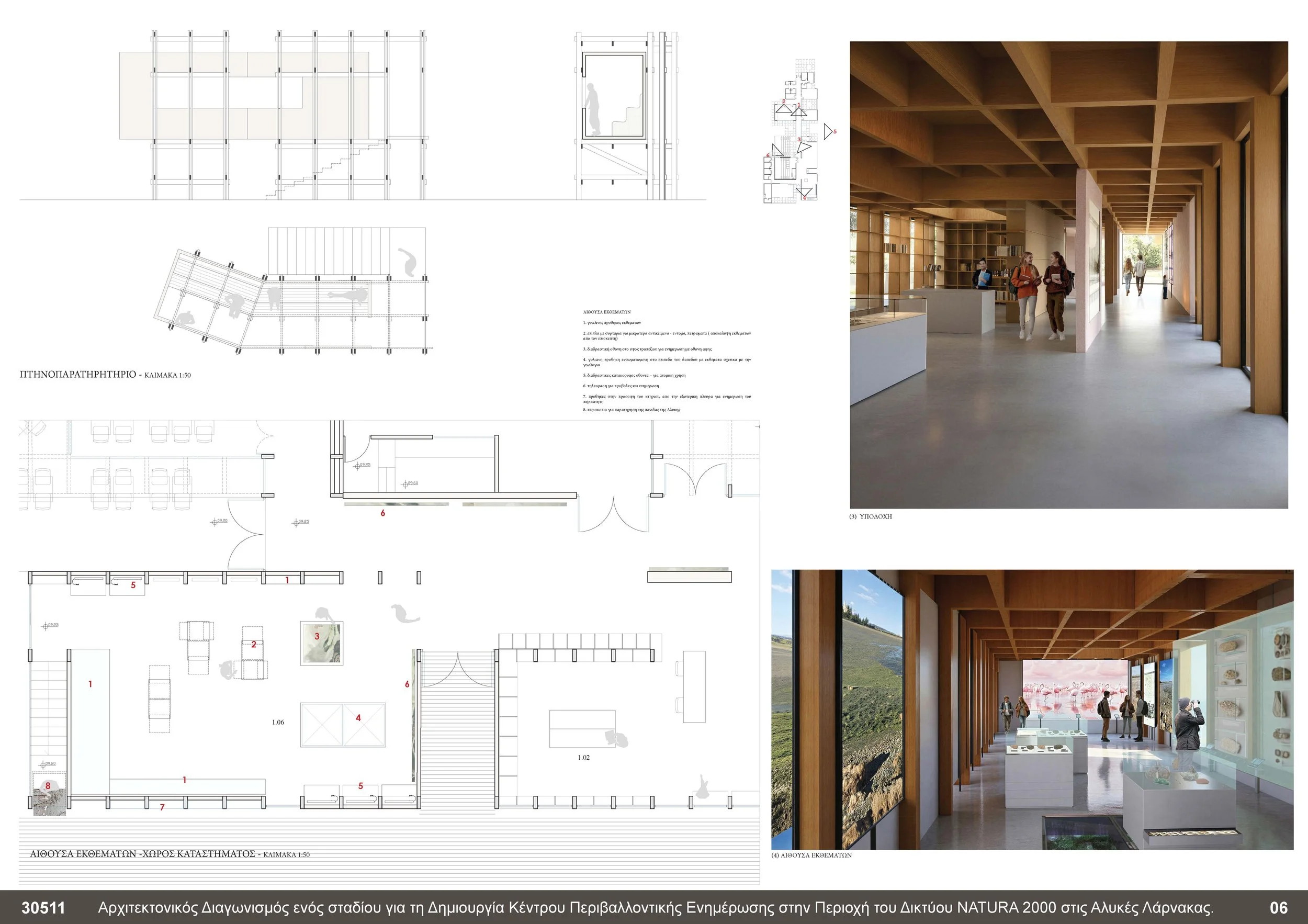
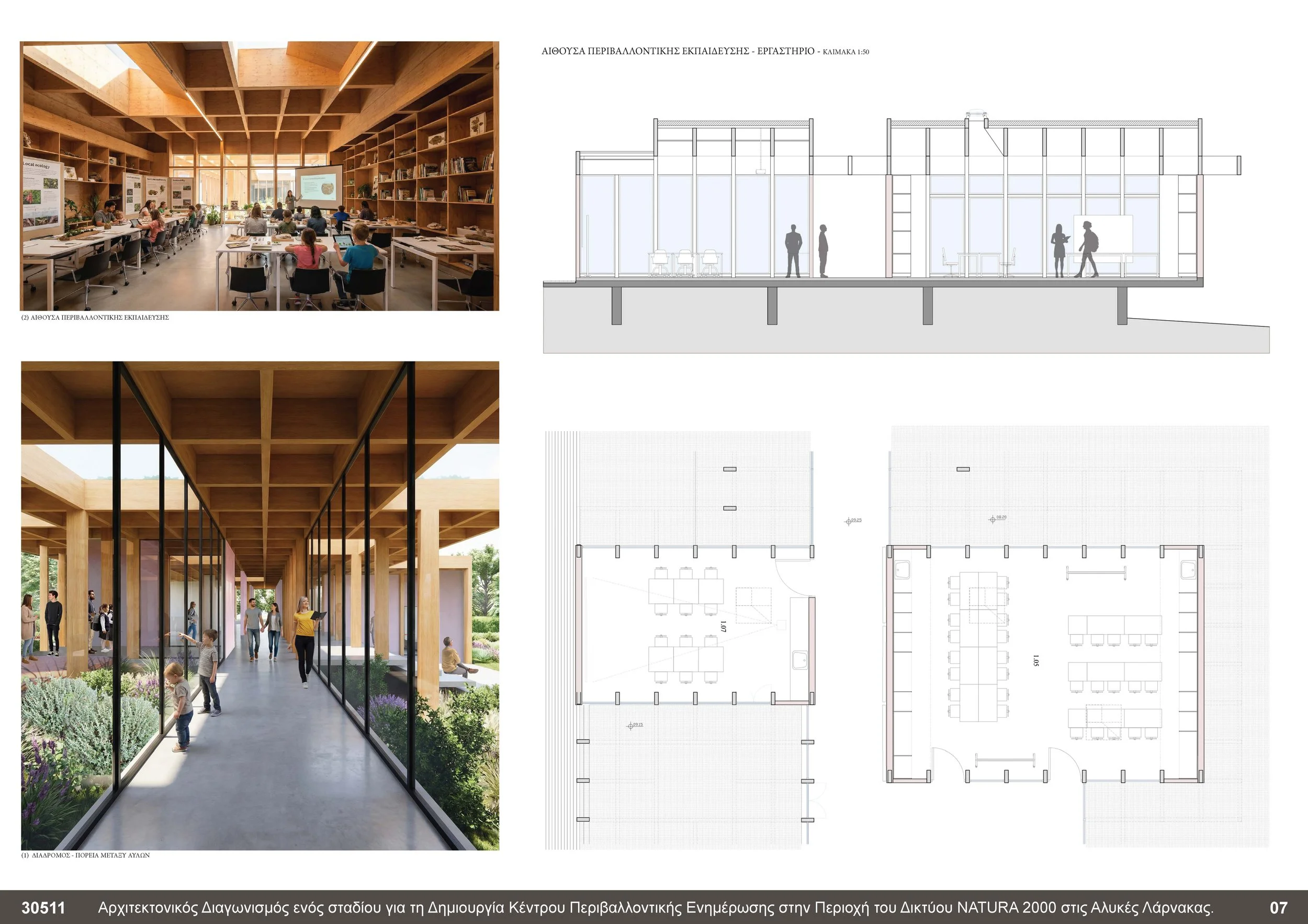
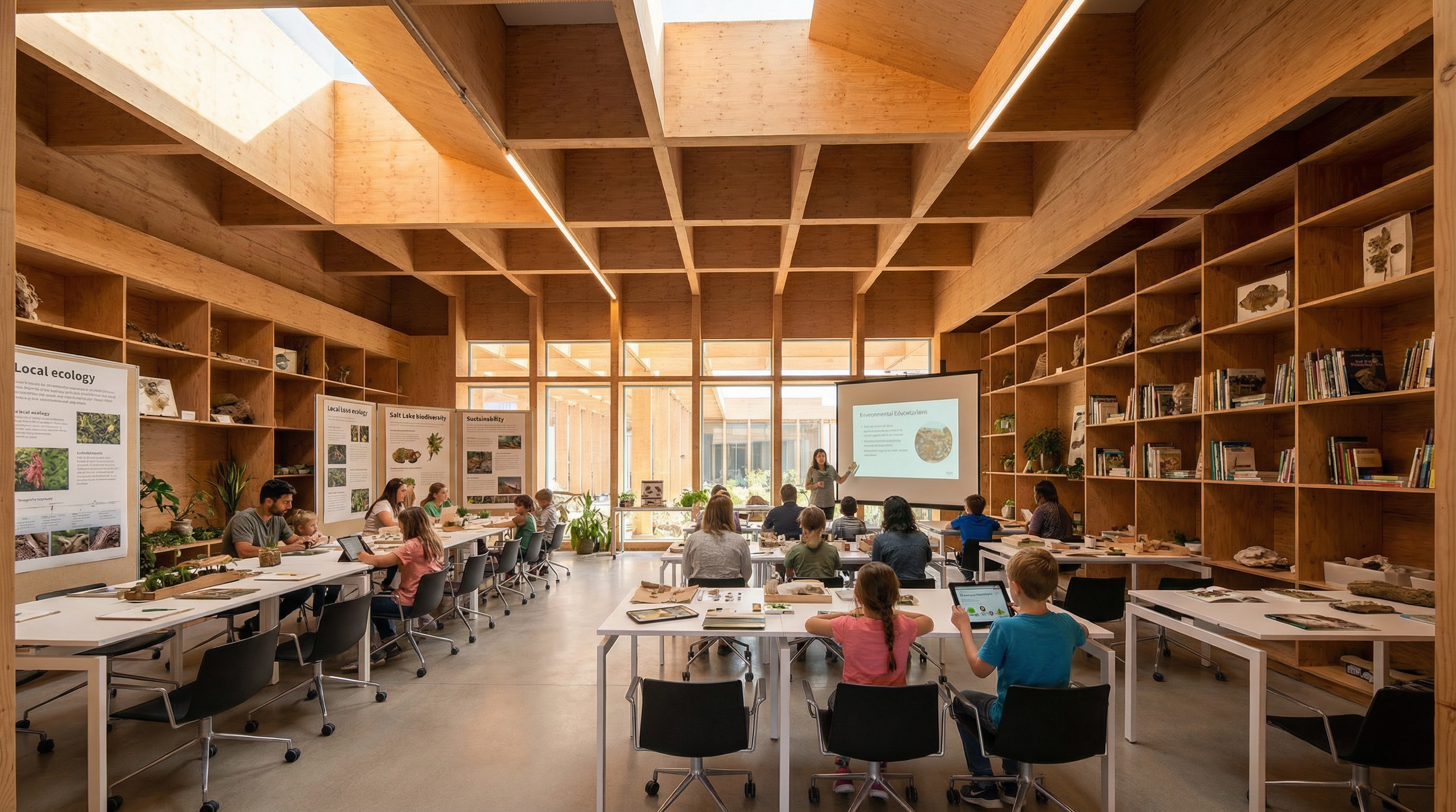
ENVIRONMENTAL EDUCATION ROOM
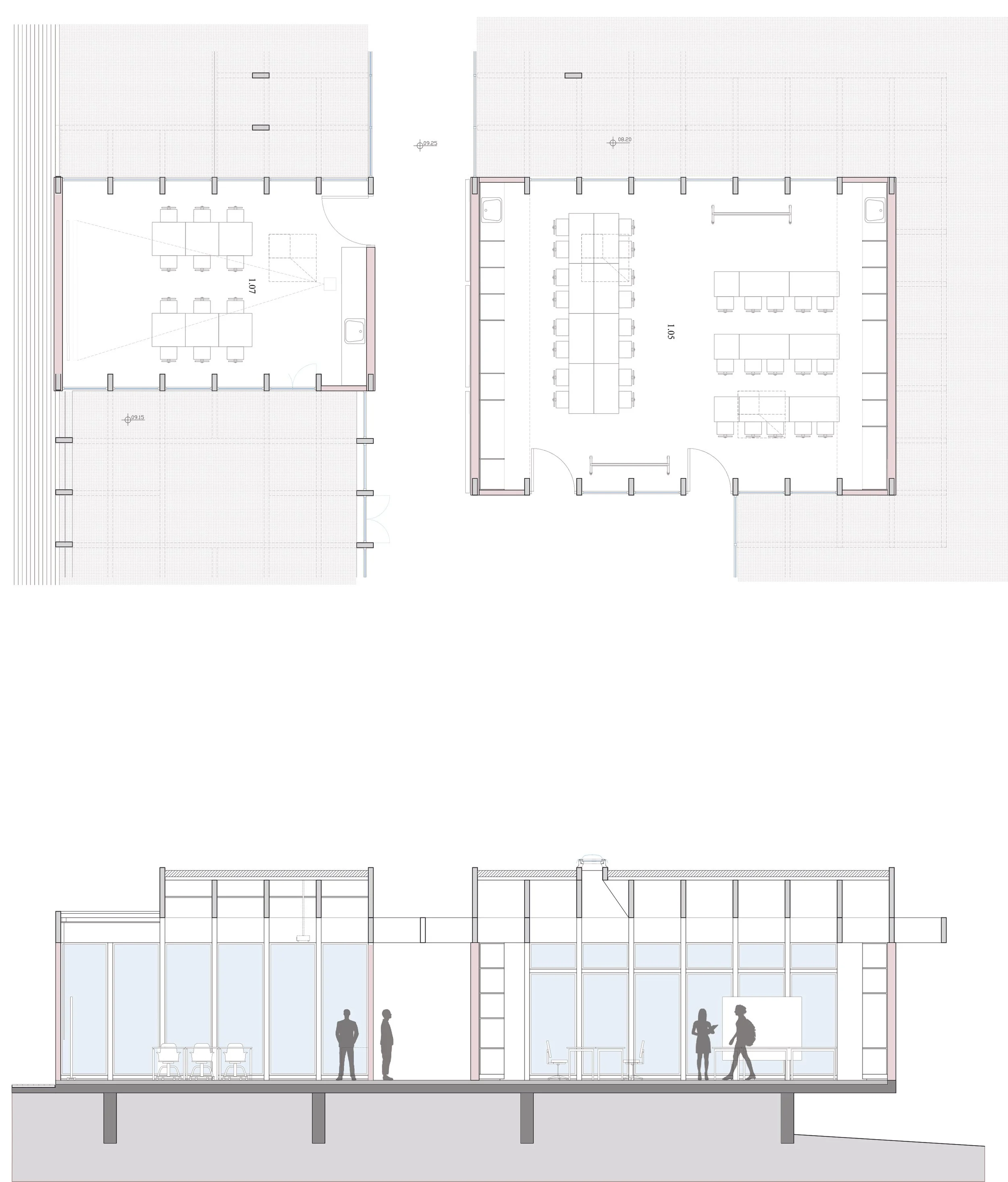
EXHIBITION ROOM
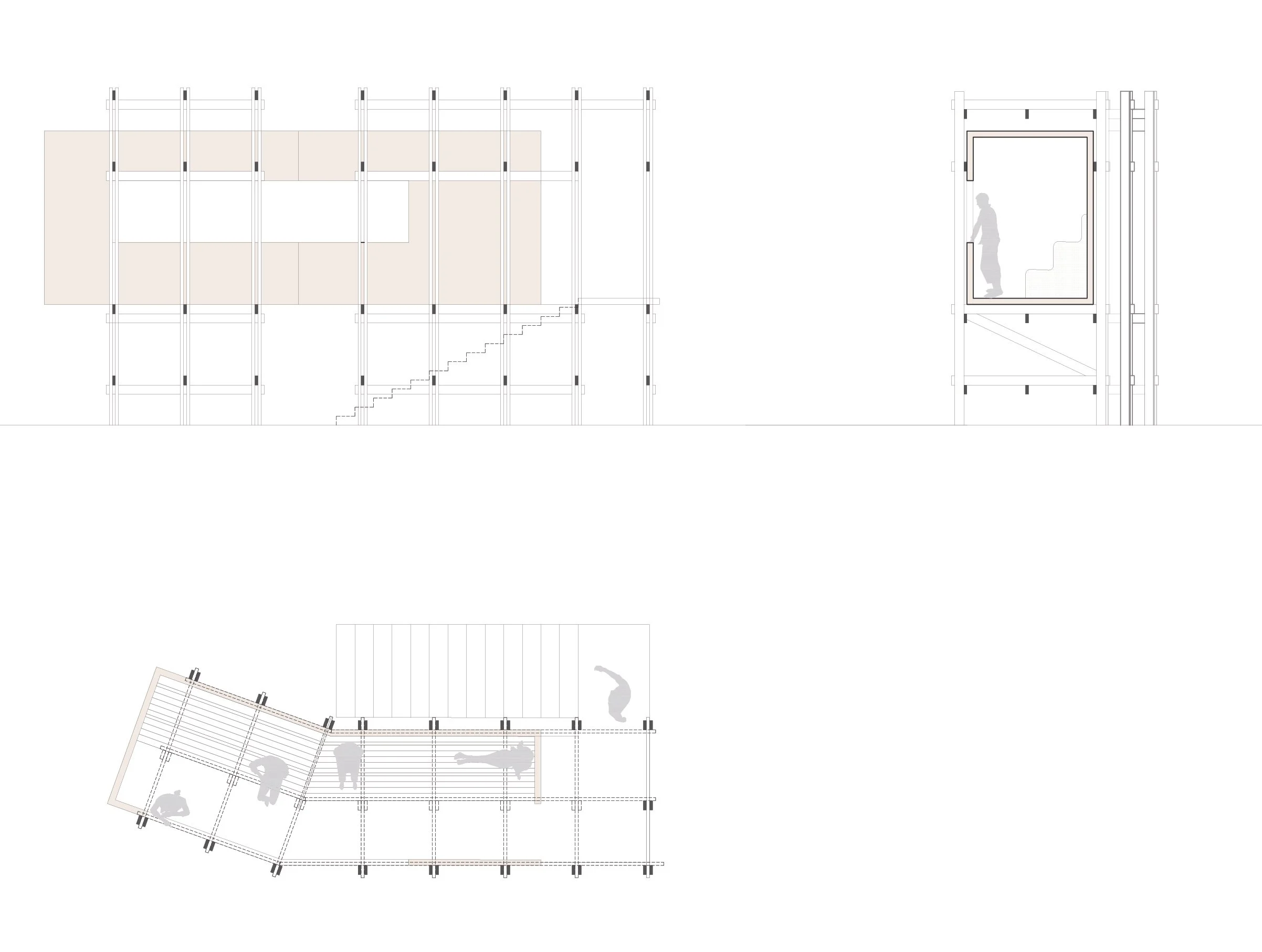
OBSERVATORY
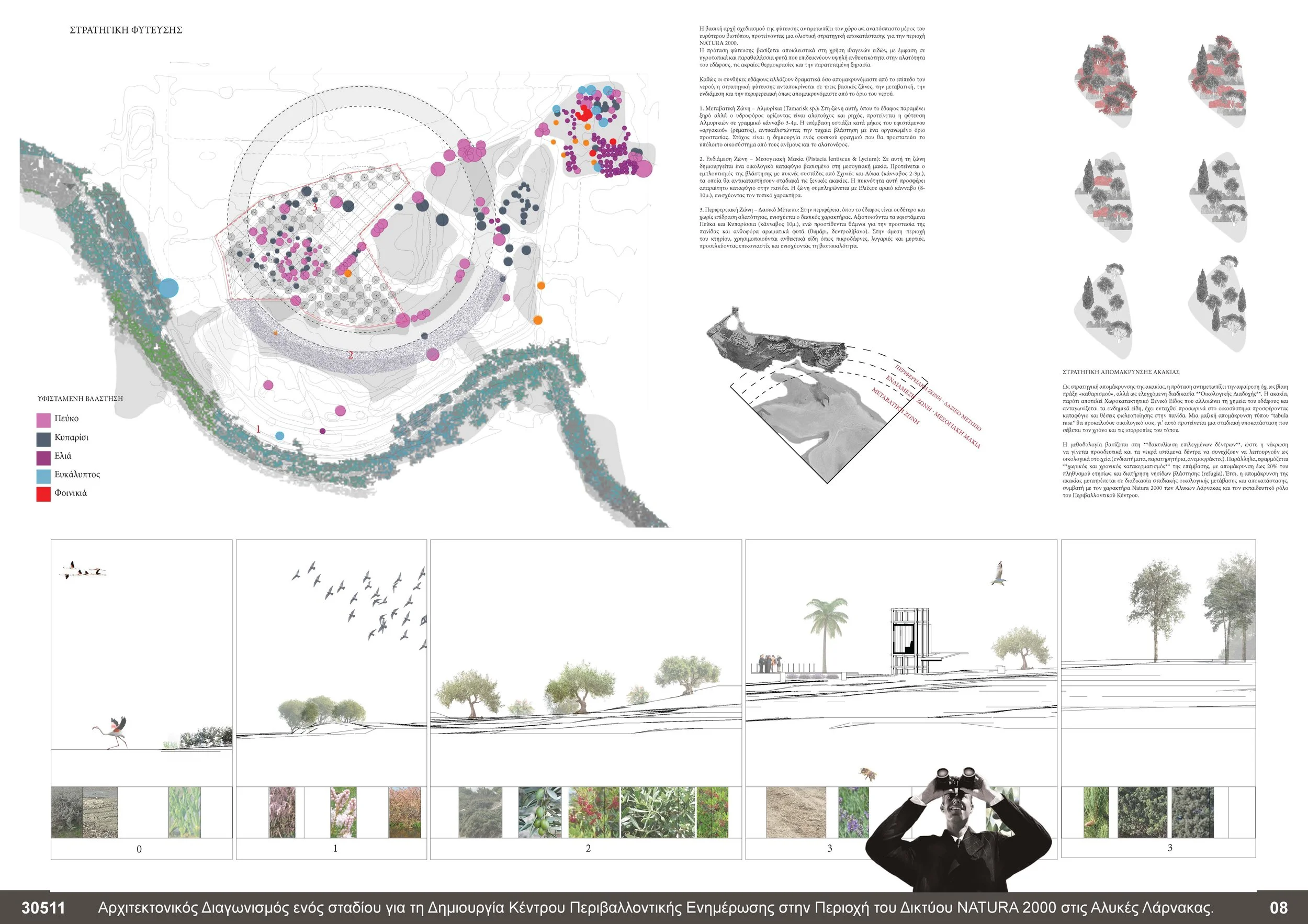
PLANTING STRATEGY
The planting strategy approaches the site as an integral part of the broader habitat, proposing a holistic ecological restoration framework for the NATURA 2000 area. Planting is based on native species, with an emphasis on wetland and coastal plants that are tolerant to salinity, extreme temperatures, and drought. Three planting methods are employed: linear arrangements, a 10 m grid, and shrub islands that emulate the natural growth patterns of acacia.
Linear planting is applied to restore linear boundaries, such as the “Argaki” with tamarisks (transitional zone) and the Plateau of Memory with low shrubs (intermediate zone – Mediterranean maquis).
Grid planting is applied to the “Forest” and “Olive Grove” areas (zones with dry-stone constructions, located between the diagonal and central pathways).
Island planting is ideal for the gradual reintroduction of acacia saplings without disturbing the local fauna, and is located in the intermediate and peripheral zones.
As soil conditions vary significantly with distance from the water level, the planting strategy responds to three primary zones—transitional, intermediate, and peripheral—corresponding to the distance from the water’s edge.
panels